eNews
#05 2023
Putting the Western Cape September rainfall event into perspective
By Sagwati Maswanganye, Instrument Technician, Fynbos Node, NRF-SAEON
The Dwarsberg rain station in the Jonkershoek catchment in Stellenbosch is known for receiving high rainfall and currently holds an unofficial record for the highest annual rainfall recorded at 4564 mm received in 1977. However, according to the South African Weather Service (SAWS), the Bushwood rain station in Limpopo province received 4359 mm in 2000, which is recognised as the official current South African record annual total. It is likely these records were submitted to SAWS for verification, resulting in the current record located approximately 1800 km to the northeast of Jonkershoek.
In September 2023, SAWS issued a storm warning for the Western Cape and this event was poised to break records. The SAEON platforms are well-suited to tracking these extreme events and SAEON staff decided to analyse the event and compare it to previous September records. SAWS kindly agreed to supply the necessary data for the comparative analysis.
The SAEON research platform is in the Jonkershoek catchment (G22F) 10 km south-east of Stellenbosch and 60 km east of Cape Town. The catchment, which is approximately 146 km2, is the main source of the Eerste River which flows through Stellenbosch and drains into the ocean in False Bay.
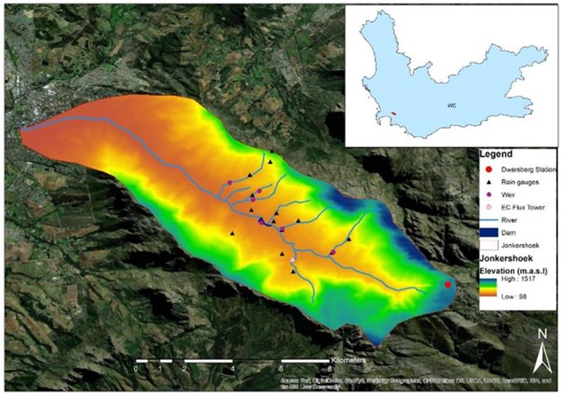
The Dwarsberg rain station can be found on the Dwarsberg plateau at the closed end of the valley at an elevation of 1214 m.a.s.l within the Hottentots Holland Nature Reserve. The catchment’s monitoring infrastructure consists of rain gauges, weather stations, weirs and an eddy covariance flux tower (Figure 1).
Figure 1: Location of Dwarsberg weather station (red circle) in Jonkershoek, Stellenbosch in reference to the Western Cape province (top right). The image also shows rivers, the topography and SAEON monitoring sites.
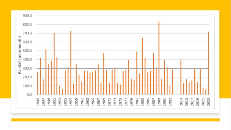
Figure 2: September rainfall totals for the Dwarsberg station spanning 1945 to 2023 (excluding 1994–2013).
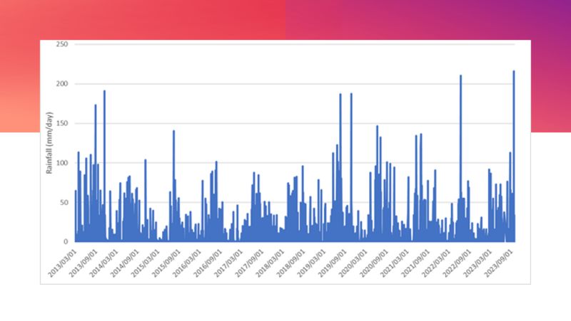
Figure 3: Daily rainfall from March 2013 to October 2023.
Catchment monitoring history
The valley played an important role as a research platform for catchment hydrological experiments since its establishment in the 1930s. Over the years there has been a series of custodians that have expanded or upgraded the monitoring station, resulting in an ~80-year rainfall record (see Table 1) explained in detail in Slingsby et al. (2021). During 1991–2009, the catchment records were maintained by volunteers, resulting in infrequent record collection, making it difficult to extract reliable monthly rainfall totals and therefore not included in this analysis.
Table 1: Summary of the governance and monitoring instruments used in this analysis in Jonkershoek over the period 1945–2023
| Year | Instrument | Timestep | Custodianship |
| 1945–1980 | Snowdon rain gauge with Nipher shield | Monthly | JRFC |
| 1980–1991 | Snowdon rain gauge with Nipher shield | Monthly | CSIR |
| 1991–2009 | Snowdon rain gauge with Nipher shield | Monthly | Volunteers |
| 2013 to date | Tipping rain gauge on a weather station | Hourly | SAEON |
*JFRC = Jonkershoek Forestry Research Centre
Analysis of rainfall in the month of September across all years
Overall, the Dwarsberg station received 717.3 mm in September 2023, with the previous high recorded in 1989, making this potentially the wettest September in 34 years (1 in 30 years occurrence). The average September rainfall for the station since 1945 is 297 mm. In comparison, the highest monthly record over this period was for June 1962, when the station received a total monthly rainfall of 1320 mm.
SAEON was convinced that the September rainfall event would be among the highest at Dwarsberg, as SAWS also indicated that 24 of their stations in the Western Cape exceeded previous records for the month of September. Some of these records have been standing since 1971.
From 2013, SAEON’s upgrade in rain gauge technology in Jonkershoek has made it possible to determine hourly and daily rainfall at remote and high-elevation sites. For the Dwarsberg station, a new 24-hour record was set. A total daily rainfall of 216 mm was recorded on 25 September 2023. This is after receiving 160 mm the previous day.
The 376 mm received over the 48-hour period is therefore the highest rainfall recorded over 48 hours since daily records began in 2013 (Figure 3). The maximum rainfall intensity from 24 to 25 September 2023 was 21.6 mm/hr, occurring between 02:00 and 03:00 on 25 September. For comparison, the highest hourly rate received by the station was 39.62 mm/hr recorded on 15 November 2013.
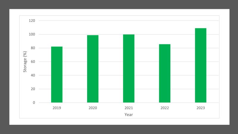
Figure 4: Total storage of dams that supply the City of Cape Town on 26 September, for the years 2019 to 2023.
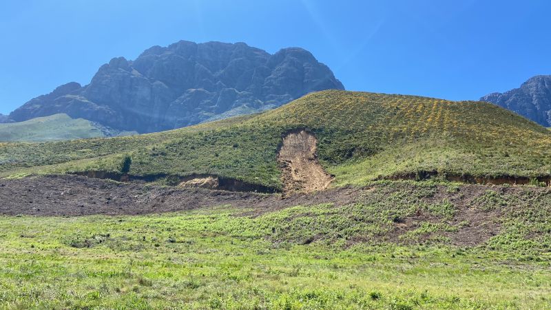
Landslide in Jonkershoek.
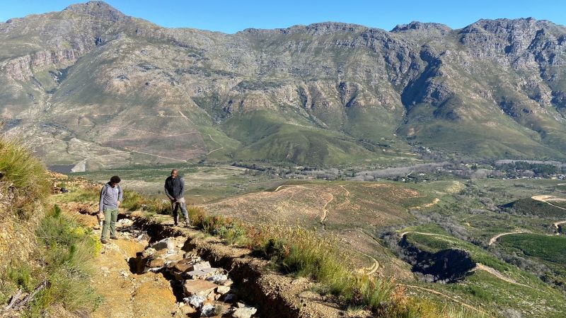
Members of the Fynbos Node team inspect the damage to the road.
Extreme rainfall events have favourable and unfavourable impacts
Climate change predictions expect that while annual rainfall is not likely to change and increase, events of short duration but high intensity are likely to occur. While this was not an exhaustive analysis, it places the current event in a historical context.
The intensity of the events can cause significant damage and overwhelm infrastructure. For example, the rainfall measured for this event was of the same magnitude as the event that caused devastating floods in KwaZulu-Natal in April 2022.
However, the rains were beneficial in contributing to dam water supplies. Many of the City of Cape Town dams are close to or over 100%. The dam storage increased by 7.1% from the rains that occurred between 19 to 26 September, reaching 109.1% of the 898 221 ML capacity (Figure 4). The city’s dams have not been this full during the month of September since 2014. The Kleinplaas balancing dam in the Jonkershoek catchment was also overflowing at that time.
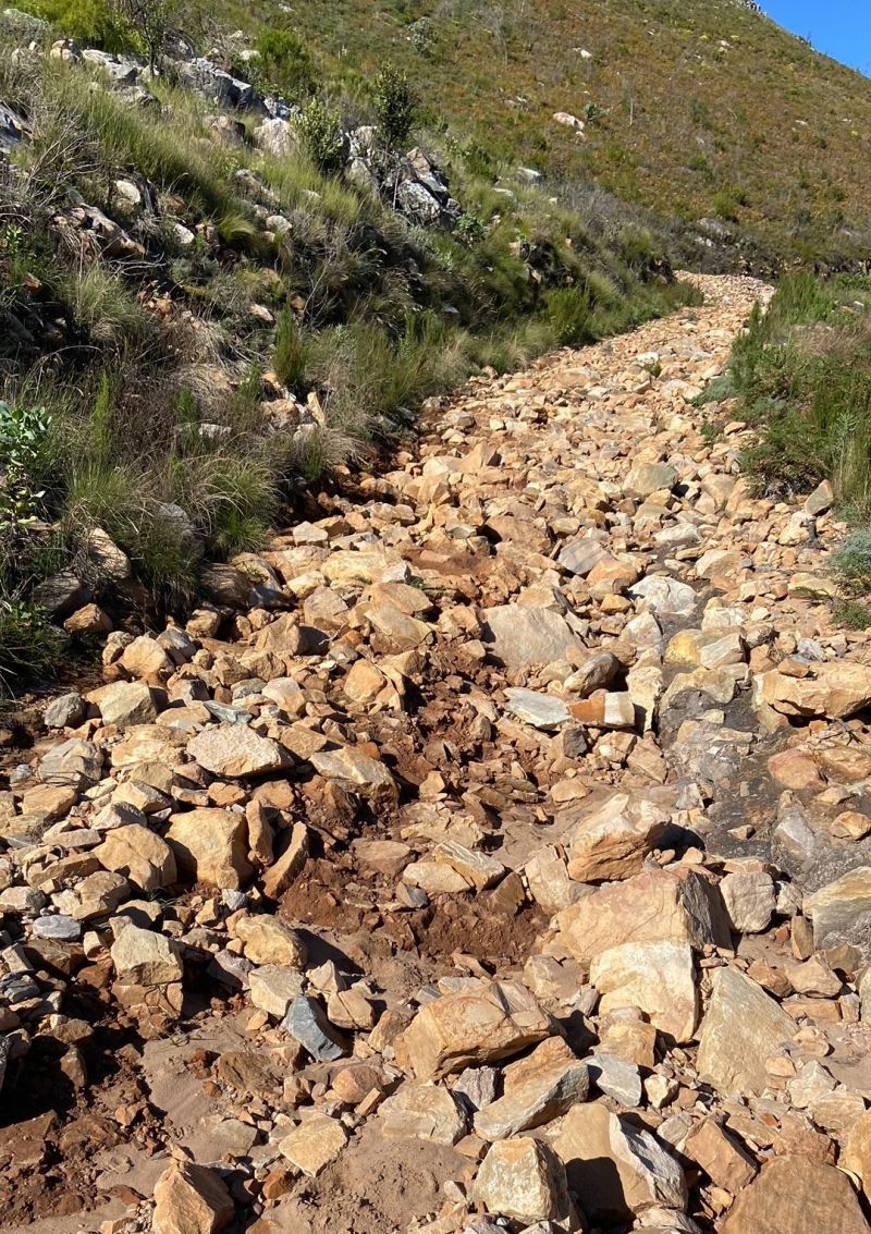
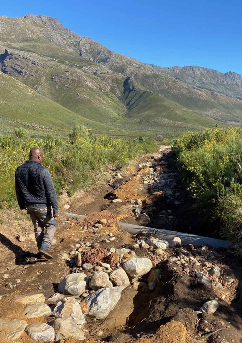
The catchment experienced significant damage in places, with landslides and roads being washed away blocking access by SAEON staff to research infrastructure.
Damaged roads in Jonkershoek.
This brief analysis demonstrates that long-term environmental monitoring is essential as it helps researchers to identify trends and put events such as this into context by referring to the past record. While it was not the highest rainfall recorded for Jonkershoek, it was the highest recorded in the last 10 years. Long-term monitoring helps us understand these changes and the impact they have on life on earth, therefore improving predictions of future events which can help us prepare better for events such as these.
Acknowledgements: Cape Nature and the MTO Group for the site permission. SAWS for providing the data.
Further reading
https://www.weathersa.co.za/home/climateques
Slingsby, J.A., de Buys, A., Simmers, A.D.A., Prinsloo, E., Forsyth, G.G., Glenday, J. & Allsopp, N. 2021. Jonkershoek: Africa’s oldest catchment experiment – 80 years and counting, Hydrological Processes., pp. 0–3. doi: 10.1002/hyp.14101

